Written by Brian Jensen, Courtesy of Fishing with Maps by Fishing Hot Spots
You’ve probably noticed, I’ve been focusing my blog posts on fishing maps lately. There’s a really good reason for that. According to a recent survey of anglers, we found that fishing maps were voted as the “most reliable source of information” when planning a fishing trip, followed by friends and bait & tackle shops. So, how can you tell the difference between the maps available and which one will be the best option for you?
There are five types of fishing maps available to anglers. I’ve included information about each of them below and arranged them in order based on the amount of fishing information they provide, starting with the least and ending with the most detailed fishing maps. Take a look and let us know which type of map you prefer.
- Overview maps – These include county, state and regional maps. This would also include Google, Bing, MapQuest or other interactive maps (although these interactive maps usually provide much more detail and information than traditional paper maps). These maps locate lakes and streams as well as major road systems and political boundaries. They also show some landmarks and businesses. In general, overview maps can help you get to the launch or shore spot and potential watering holes so you can share your fishing experiences (in addition to Fishidy.com of course).
- Topo Maps – These maps, produced by the USGS in paper format, take it a step further. They show land contours plus more definitive political boundaries, in addition to some manmade water features like access points, bridges and dams. Take note though — some of these maps can be very dated.
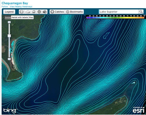
- Navigation Charts – These are commercially available and generally made for large, commercially navigable rivers, large reservoirs, seawaters and the Great Lakes. These maps tend to have high-definition when it comes to navigation and depth contours. They typically show buoys, channels, piers, reefs, shoals and hazards. They also tend to be quite costly.
- Lake or River Maps – Maps of this type concentrate on water depths and sub-surface structures. Lake maps show little of the surrounding area and road information. They are typically lake surveys, don’t necessarily display accurate fishing information and are often dated. These are generally available in PDF or paper format.
- Fishing Maps – Quality fishing maps feature an accurate contour/depth map, but also offer first-rate fishing and navigational information. Created specifically for anglers, these maps show water features essential for locating fish and fishing structure such as weedbeds, brush piles, channels, flooded timber, etc. Some even show field verified hot spots (i.e. Fishing Hot Spots and Fishidy.com).
Today’s fishing map-makers, like Fishing Hot Spots and Fishidy.com, use the latest computer, mobile, web- and location-based technologies to create maps that are accurate, colorful, valuable and contain loads of detailed information. Quality fishing maps provide great detail on the surface and the underwater world of fish.
Check out the maps on Fishidy.com and let us know what you think!


