By: Brian Jensen, President of Fishidy.com
Fishidy is happy to announce new mapping features. Whether you’re chasing Smallmouth Bass, Perch, King Salmon, Walleye, Lake Trout or any other trophy species found in the largest group of freshwater lakes on Earth, the Great Lakes are some of the best freshwater fisheries in the world. And now, we have Great Lake anglers covered on Fishidy!
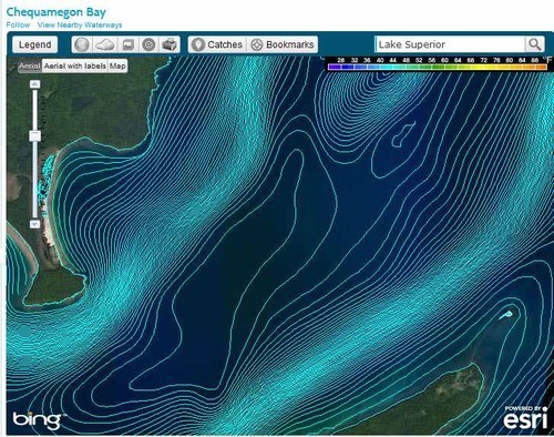
Here’s a look at the contours on our Lake Superior map.
Through our partnership with Fishing Hot Spots® (FHS), we’ve added detailed contour and navigational mapping for three Great Lakes (Michigan, Superior and Huron). The new mapping provides full coverage of these three lakes and supplements our existing mapping for Lake Erie and Lake Ontario. That means Fishidy.com now provides full coverage of all five Great Lakes. Earlier this year, Fishidy added hundreds of thousands of square miles of saltwater fishing maps, thus providing almost 100% coverage of the continental United States. This added to our already impressive collection of fishing maps, which includes 4,000+ inland fishing maps, hundreds of existing saltwater fishing maps and now full coverage of the Great Lakes.
“The FHS research staff has spent countless hours collecting, processing and mapping over 78,000 square miles of water to finish the Great Lakes mapping now available on Fishidy.com,” says Brandt Brown, Director of Research of Development for FHS.
Well done guys! We’re happy to continue to provide the most comprehensive fishing maps for all types of anglers. Fishidy.com is also pleased to announce new layers available on our fishing maps that give users even more customization options for their personal fishing maps stored on Fishidy. The layers include the Fishidy basic mapping features: access points, contours and navigation, general features, 8 different weather layers, buddies’ catches, your own catches and your bookmarks. Our Premium users get access to three additional layers, Fishing Hot Spots marked areas, structures and vegetation and sea surface temperatures.
Customizing your maps on Fishidy helps anglers plan their time on the water, track and report on their fishing adventures and catch more fish!
Fishidy is working hard to expand and improve our website on a daily basis. We love hearing recommendations and feedback frorm our community so please don’t hesitate to contact us.
Check out the new Great Lakes data and mapping features now at www.fishidy.com.


