It’s been about five months since I began talking to and working alongside the folks at Fishidy. And the good news is, these guys actually know what they’re doing! I’ve gotten a lot of use out of Fishidy.com in many ways. From fishing research and lake maps to social networking and creating new fishing buddies, Fishidy continues to offer me new avenues to explore my own outdoor lifestyle.
I can’t completely explain the benefits for prefishing because they’ll be different for each person. But, I can tell you I’ve used Fishing Hot Spots (FHS) mapping information and depth contours for the last few tournaments and it has really paid off. The best part is it gives you the advantage of really understanding a body of water through and through.
When my fishing partner Tyler Netzer and I were at Lake of the Ozarks the method to our madness came down to determining a pattern. If it was going to be points, pea gravel, brush piles or steep drop offs we were ready because we knew the section of the lake we were going to fish like the back of our hands. Slate rock walls that dropped into deep water ended up being the key that particular day. Our plan was to keep matching up spots and hopping through the entire length of the lake arm until time ran out.
Don’t get me wrong, we had lulls throughout the day, but we kept grinding on! I’ve never felt so satisfied at the end of a tournament as I did that day because we were able to find a working pattern, find multiple spots that were similar because we put in our time studying, and most importantly we brought in a sack of fish that nearly won! At the end of the day we took 2nd, and the ride home was filled with talk about how we were going to do the same type of research for the next event. Well… we may have brought up some ideas of where we were going to spend our winnings, as well!
As I mentioned, the waterway maps on Fishidy are awesome! I can’t say enough about the interactive nature of these maps and how much information you can pull out of the 4,000+ maps nationwide. If I want to go fishing with my dad on Lake Winnebago for perch or walleyes, I can pull up a few FHS marked fishing spots on Fishidy as a starting point. From there I can look for my friend’s catches on the lake that were from the same time period and keep those in my back pocket. If all else fails, we can use the local bait shops marked on the maps as a place to ask about specifics at that time of the year and trending bait selections.
The ability to print the maps out and take them to the lake is extremely important to me because, until the mobile app comes out, I use maps a TON while I’m on the water. Either marking things down, checking for spots that are similar to the pattern or just for navigating the waterways. Plus, it’s nice just to pull out a map and have that tangible item in my hands.
Finally, we can mark things that may have been left off the FHS maps such as new brush piles, fish attractors and weed lines that eluded the map when it was printed. And, when all else fails, ask your Fishidy buddies! Chances are, someone you’ve connected with has fished that same waterway in the past or knows someone who has.
I currently have 70 buddies on Fishidy. I’d say my chances are pretty gosh-darn high one or more of them will have information or advice on an upcoming trip to the lake. In fact, I guarantee I have a lot of friends that’ll be willing to give me information AND go along with me.
I know that within the next six months (right around the start of the fishing season in WI) I’ll probably triple that number and will have that many more people to help me with questions. These folks have probably had many similar experiences as I have, but I know that each person also has different situations occur that I haven’t thought about or seen in my 16+ years of fishing. As a fisherman, it’s so critical to stay open minded to different methods, crazy baits and to fish in unfamilar water to hone your skills. You never know what’s going to produce on any given day.
Outside of fishing I’ve been doing a lot of research on Fishidy that pertains to hunting. In Wisconsin, the gun/deer season is an annual tradition that attracts a lot of attention. I thought Fishidy would be as great resource for planning for the big hunt and “Da Thirty Pointer” as it is for chasing the dream of catching that elusive 50+ inch musky! I’ve had a trail camera up for a month now snapping pictures and helping me create a game plan for November 19th.
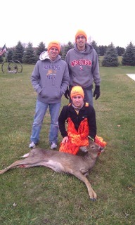
By using the mapping technology on Fishidy, I’ve been able to put together a map for my buddies to use when we hunt a parcel of land, give them instructions, and mark stands, rubs, scrapes, food plots and places where other hunters have been in the past. I’ve also been able to look at deer trails that are visible on the satellite imagery and find the most used and even some that I didn’t know existed on the land I’ve been hunting for the last 3 years. I truly believe that the uses for these Fishidy maps are ultimately endless! (And as you can see from the photo above, my hard work paid off).
Fishidy was created for the outdoors. It was created by outdoorsmen for outdoorsmen and women, and for the better of all of us who want to get credible information when we want it and where we want it. Where else would you want to go for information other than a place that brings fisherman together for the betterment of themselves, their friends and the future success of the sport? Fishidy is a great outdoor site, And, in my opinion, it’s the future of fishing, technology and social media – all wrapped into one!
Stay Fishidy my friends.


