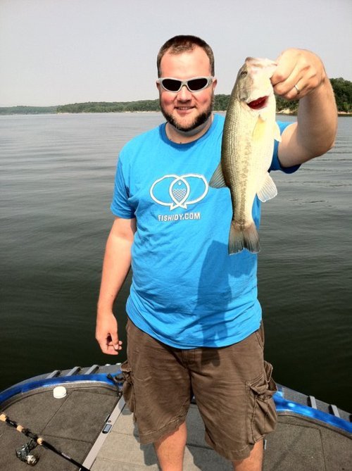
By Brian Jensen – President of Fishidy
We’ve all been there — driving home from an unsuccessful day (or in my case, week) on the water. That drive is not only shameful, thinking about the flack you’ll catch from all your buddies, it’s also disappointing. No serious angler intends NOT to catch fish!! But mostly it’s just agonizing — should I have used chartreuse instead of firetiger, did the weather change have that big of an impact on the fish, and most notably, was I even fishing in the right spots?!?
I was in this exact “drive of shame” about four years ago following a weeklong fishing trip to beautiful Lake of the Woods. That’s when it dawned on me…there had to be a better way! I had spent the weeks prior to my trip re-spooling my reels, sharpening my hooks and of course, spending hours researching how and where to fish. When I left home, my boat was charged and fueled up, my hooks could cut a diamond and I had a tackle box the size of a small automobile full of chartreuse, firetiger, persian rose, and every other color/type of bait you can think of. However, I was still lacking critical knowledge about the most important variable in the fishing equation…the “where should I fish” factor.
Sure, the hours researching (mostly online) led me to forums, blogs like this one and other websites that provided some basic information. The locational information online tended to be very vague and braggadocios, yet lacking substance. Some of it really didn’t address location at all. Why was that? The answer was two-fold and pretty simple.
- First, sharing with the world just isn’t cool, especially any prized fishing spots.
- Second, there weren’t any resources online that truly presented and captured prized location information.
I remember thinking these issues could be overcome. I should mention I’m a tech junky as I’ve spent the last ten years of my professional life building software applications. This experience had me convinced that technology was the way to overcome these location-based issues anglers everywhere deal with.
That’s how Fishidy was born. During the early stages of the idea, I partnered with some other like-minded businesses and individuals that had the same experiences and the same vision. These individuals brought technology and business expertise, a ton of sweet fishing maps and a whole lot of passion to the table.
There’s no denying Fishidy is in its infancy in terms of the natural evolution of the site. Our goal as a company is to be responsive. We are passionate anglers, but we’re also imperfect anglers. We know that to be successful, we need to listen to the angling community, adapt and evolve. And, that’s exactly what we’re doing. We launched an alpha version of Fishidy in July 2011, then listened to our users and delivered a new beta version of the site this past December. Then, we listened some more and now we’re proud to announce a new version of Fishidy.com. This new version of Fishidy includes quite the list of improvements including:
- New waterway pages include profiles and ways for you to connect and follow the places you fish the most.
- Business pages show you all the businesses around the places you fish. Or, if you own a business, the ability to add it to our interactive maps.
- A comprehensive resources page features rules/regulations, fishing licenses, reservoir levels and much more – it’s a one-stop-shop for all things fishing!
- Waterway search tools help you locate new fisheries based on species preferences or location.
- Weather on the maps (precipitation, temperature, cloud cover, wind speeds and more).
- Hundreds of new mapped waterways provided by Fishing Hot Spots.
- Updated look and design.
- Increased performance and speed
- Now you can print a customizable map to take with you.
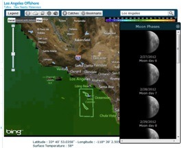
- World-wide Sea Surface Temperatures at your fingertips.
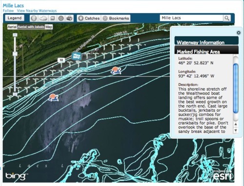
- Thousands of new proven, marked fishing spots on thousands of waterways across the country provided by Fishing Hot Spots!
And guess what? This process of making ongoing improvements isn’t going to stop. We’ll continue to listen, adapt and evolve. We have new features and enhancements planned forever – seriously. This spring we’ll be introducing a Fishidy mobile site, GPS integration and a new and improved mapping interface. The list goes on and on…
Fishidy is a community. By working together we can make it an even better resource for everyone. The more you put into it, the more you get out of it. That means making connections with other anglers, following the bodies of water you fish, connecting with businesses around those waterways, and sharing information with your trusted connections. That’s the beauty of Fishidy — you control how information is shared and how information comes to you – well, that and our ridiculous number of detailed fishing maps!
Fishidy is your community and your resource. Please keep the feedback coming, keep connecting and keep the lines tight!
Stay Fishidy.


